BioScriba v.2 n.1 Bahía Blanca abr 2009
Resúmenes:
ANÁLISIS REGIONAL DE LA COSTA PAMPEANA AUSTRAL EN EL MARCO DEL SISTEMA DE ÁREAS PROTEGIDAS Y CARACTERIZACIÓN DE UN ÁREA CLAVE COMO RESERVA, EN EL PARTIDO DE CORONEL DORREGO
Monserrat1 Ana Laura y Cintia Eleonora Celsi2
1 Laboratorio de Geología Marina y Dinámica Costera. Dto. de Ciencias Geológicas. FCEN-UBA/CONICET. neltume23@yahoo.com.ar
2 Proyecto Costas Bonaerenses. Fundación de Historia Natural Félix de Azara. Valentín Virasoro 732 (C1405BDB), Cdad. de Bs. As. Argentina, gestion.costas@fundacionazara.org.ar
Resumen
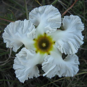
Las dunas costeras de Buenos Aires son modificadas por actividad antrópica. Se reconoce la necesidad de mantener los servicios ecosistémicos que brindan. Zonificamos la costa marítima entre Centinela del Mar y Punta Alta, según su geomorfología y vegetación. Evaluamos la representatividad de cada sección determinada dentro del Sistema de Áreas Naturales Protegidas. Caracterizamos el sector de mayor continuidad y mejor estado de conservación. Describimos sus ambientes característicos y las asociaciones vegetales. Diferenciamos 5 secciones de la región; sólo dos contienen áreas protegidas, una abarca campos de dunas (2.6 % de la sección). Sólo el 0,6 % de los campos de dunas de la región presenta protección legal. En Coronel Dorrego identificamos 94 plantas vasculares (28 familias, 16 % especies exóticas). Predominan herbáceas sobre leñosas (80 vs.20%). Encontramos mayor riqueza en bajos interdunales y montículos interiores fijos/semifijos, y especies endémicas: Senecio bergii y Baccharis divaricata. Las dunas costeras de la Pampa Austral están subrrepresentadas en el sistema de áreas protegidas. Son necesarias la detección de sitios claves para la conservación, su propuesta e implementación como nuevas áreas naturales protegidas, y la ampliación de las existentes. La costa de Coronel Dorrego, el sitio de mayor continuidad y mejor estado de conservación, no posee protección.
Palabras claves: Costa, médanos, reservas naturales, Dorrego.
Abstract
The coastal dunes of Buenos Aires are modified by human activity. The necessity to maintain their ecosystem services is widely recognized. We zonified the marine coast between Centinela del Mar and Punta Alta, according to its geomorphology and vegetation. We evaluated the representativeness of each section within the System of Natural Protected Areas. We characterized the section of greatest continuity and best state of conservation. We described its characteristic habitats and vegetation associations. We differentiated five sections within the region; only two contain protected areas, one contains dunes (2.6% of the section). Only 0.6% of the dunes of the region present legal protection. In Coronel Dorrego we identified 94 plant species (28 families, 16% exotic species). Herbs predominate over woody species (80% vs. 20%). We found the greatest richness in dune slacks and fixed/semifixed mounds, and the endemic species: Senecio bergii and Baccharis divaricata. The coastal dunes of Austral Pampas are under-represented in the System of Protected Areas. It is necessary to detect key areas for conservation and to implement them as new natural protected areas, as well as extending existing ones. The coast of Coronel Dorrego, the site of greatest continuity and best state of conservation, lacks of protection.
Keywords: Coast, dunes, nature reserves, Dorrego.
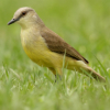
RIQUEZA ESPECÍFICA DE AVES EN UN ÁREA MILITAR EN EL PARTIDO DE MAGDALENA, PROVINCIA DE BUENOS AIRES, ARGENTINA
Zamorano, Martín1 ,2, Gonzalo Daniele2, Daniela Bottino2 y Javier Negrete1 ,2
1 CONICET. División Paleontología Vertebrados, Facultad de Ciencias Naturales y Museo, UNLP, Paseo del Bosque s/n, 1900 La Plata
2 Cátedra Zoología III, Vertebrados. Fac. de Ciencias Naturales y Museo de la Universidad Nacional de La Plata. Calle 520 nº 1115 (1901) Ringuelet, La Plata. marzamorano@fcnym.unlp.edu.ar
Resumen
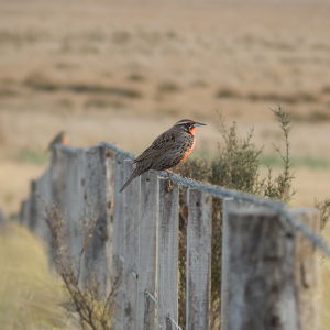
Se registra la riqueza específica de aves en un área militar. Dicha zona pertenece al partido de Magdalena y desde el punto de vista fitogeográfico está ubicada en el Dominio Chaqueño, Provincia del Espinal, Distrito Algarrobo, Subdistrito del Tala. Es una zona con alta biodiversidad en la provincia de Buenos Aires. En el marco de un proyecto que abarca todos los grupos de vertebrados se censaron las aves, se discriminaron por ambientes y se tuvo en cuenta el probable impacto ambiental en el área. Los porcentajes de especies de aves observadas por ambiente fueron: Bosque 40% (correspondiendo 32% al bosque nativo e incrementándose en los bosques con exóticas, 8%), zona ribereña 32.5%, pastizal 12.5%, y 15% en más de un ambiente.
Palabras claves: Aves, riqueza, área militar, impacto ambiental..
Abstract
The specific richness of birds was recorded in a military area in the district of Magdalena, which is located in the Chaqueño Dominion, Province of Espinal, Algarrobo District, Subdistrict of Tala. It is an area of great biodiversity in the province of Buenos Aires. A bird census was carried out as part of a project on vertebrates. They were recorded by habitat and the probable environmental impact in the area was considered. The percentages found were: woods 40% (32% in native woods and a further 8% in woods with exotic trees), river coastal zone 32.5%, grassland 12.5% and 15% in more than one environment.
Keywords: Birds, richness, military area, environmental impact.
DISTRIBUCIÓN DE LOMBRICES ROJAS (Eisenia fetida y Eisenia andrei) EN EL INTERIOR DEL SUSTRATO / ALIMENTO. INCIDENCIA EN LA ESTRATEGIA DE CONDUCCIÓN DEL LOMBRICULTIVO.
Schuldt Miguel1, Rodolfo Christiansen2,3, Juan P. Mayo2, Luís A. Scatturice2, Christián Pessin2,4, María A. Helling2,4, Ivana Illanes2, Carlos Gaspar2 y José M. Rubinich2
1 Conicet, AER INTA El Bolsón, Mármol s/n, 8430 El Bolsón, Prov. Río Negro;: miguel_schuldt@hotmail.com;
2 Universidad Nacional de la Patagonia Austral (UA Río Turbio); 3 INTA Río Turbio; 4 Consejo Agrario Provincial (Sta. Cruz).
Resumen
En lombricultivos de la Cuenca Carbonífera de Río Turbio (Prov. Santa Cruz, Argentina), sobre la base de muestreos periódicos y estratificados, se analizó la distribución de la población de lombrices discriminada por categorías etarias (cocones, juveniles, subadultos y adultos) en el interior del sustrato orgánico que les sirve de medio de cultivo (estiércol ovino y aserrín de Lenga –Nothofagus pumilio). Se observó que: a) Eisenia fetida y E. andrei ingresan al sustrato, procesando con mayor intensidad los estratos superiores, albergando los primeros 20 cm el 78% de la población y alcanzando densidades en torno a 200.000 lombrices por Lecho (c/2 m2). Sólo escasos animales juveniles permanecen en estratos mas profundos (de 40 a 60 cm); b) En los cultivos también se hallan Oligoquetos Enquitreidos provenientes del medio natural circundante que se distribuyen siguiendo un patrón similar al de las Eisenia ssp.; c) La limitación de las lombrices para ingresar a profundidades mayores de 40 cm acota las estrategias de conducción de los vermicultivos cuando el rigor climático determina un manejo invernal en pila alta, haciendo que los estratos profundos queden fuera del accionar de las lombrices, obligando a operar sobre el sustrato en primavera para ponerlo al alcance de los animales (disminuir la altura de la pila). La primavera permite implementar la conducción del cultivo mediante alimentación periódica (en caso de interesar el aumento del tamaño de la población de lombrices) en pila baja hasta el otoño.
Palabras claves: Eisenia ssp., Distribución interior cultivo, Conducción lombricultivo..
Abstract
The distribution of different stages of worm populations (cocoons, young, sub-adults and adults) in organic substrate that serves as culture media (sheep manure with Lenga (Nothofagus pumilio) sawdust) in vermicultures in the Rio Turbio coalfields (province of Santa Cruz, Argentina) was analyzed on the basis of periodic and stratified sampling, It was observed that A) Eisenia fetida and Eisenia andrei that enter the substrate are found mainly in the superior strata (78% of the population in the first 20 cm) and reach densities of 200,000 worms per bed (c/2m2) whilst only few young can be found from 40 to 60 cm. B) Oligochetae Enchitreidae from the natural surroundings are also found in the culture and they follow the same distribution patterns as the Eisenia spp. B) The fact that worms do not go deeper than 40 cm. into the substrate, limits the conduction strategies for the vermicultures during the cold winters when the beds are taller and the deeper strata remain out of range to worm activities. The height of the piles has to be lowered in spring so that the worms can operate when the climate improves (if an increase in the population is wanted).
Keywords: Eisenia spp. Distribution inside the beds. Vermiculture conduction.
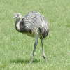
PRIMER RELEVAMIENTO DE LA AVIFAUNA DELSECTOR COSTERO DEL PARTIDO DE CORONEL DORREGO, PROVINCIA DE BUENOS AIRES, ARGENTINA.
Folguera Laura y Ana Laura Monserrat
1 Facultad de Ingeniería. Universidad de Flores,
2 Laboratorio de Geología Marina y Dinámica Costera. Dto. Geología. FCEN-UBA/CONICET. laurafol@ciudad.com.ar
Resumen
La fauna de vertebrados de la barrera medanosa austral de la costa bonaerense posee escasos datos de registro. Presentamos el primer relevamiento sistemático de la avifauna de la zona costera de Coronel Dorrego. Mediante transectas en playa y puntos focales en las dunas se estimaron riqueza específica, diversidad y uso de ambientes y unidades geomorfológicas. Se registraron 50 especies (27 familias, Icteridae y Accipitridae mejor representadas), todas autóctonas. Se encontraron mayor abundancia en ambientes y geoformas de río y mar, y mayor diversidad y riqueza en geoformas y ambientes de río y campo de dunas. Resulta imprescindible conservar todos los tipos de ambientes de la zona dado que pertenecen al conjunto de ambientes costeros pampeanos, en actual retroceso y que cada uno contiene un ensamble de especies diferente.
Palabras claves: costa, médanos, aves, Coronel Dorrego.
Abstract
Records of fauna in the coastal dunes in southern Buenos Aires province are scarce. We present the first bird survey for the Coronel Dorrego coastal zone. We carried out transects on the beach and point-counts in the dunes to estimate species richness, diversity and use of habitats and geomorphologic units. We recorded 50 native species (27 families). The greatest abundance was found in river and marine habitats whereas the greatest diversity and species richness were in the river and dune habitats. Conservation of all types of habitats is essential given that they belong to the Pampas ecoregion which is in a current state of decline and each one of them contains a different group of species.
Keywords: coast, dunes, birds, Coronel Dorrego.
DETERMINACIÓN DEL ESTADO TRÓFICO Y DE LA CAPACIDAD DE CARGA DEL EMBALSE CASA DE PIEDRA (ARGENTINA)
Echaniz, Santiago y Alicia Vignatti
Facultad de Ciencias Exactas y Naturales, UNLPam. Avenida Uruguay 151. 6300. Santa Rosa, La Pampa. sechaniz@cpenet.com.ar
Resumen
El monitoreo de la calidad del agua de un embalse es fundamental para planificar su gestión y los usos que se puedan realizar. Entre los factores a considerar están las concentraciones de nutrientes (fósforo y nitrógeno), principales responsables del estado trófico. El cultivo de peces en un ecosistema acuático aporta nutrientes, por lo que repercute en su nivel trófico. La capacidad de carga es la biomasa íctica que puede ser mantenida sin sobrepasar el estado trófico. Dado que desde fines de 2005 se introdujeron jaulas para cría de truchas arco iris en el embalse Casa de Piedra, los objetivos de esta contribución son presentar resultados del análisis del estado trófico, comparándolos con información previa y el cálculo de la capacidad de carga, en base a datos tomados en el río y el embalse en octubre de 2007. Tanto las cantidades de nutrientes que llegan por el río y las del embalse, la retención de éstos, el estado trófico y la transparencia, no han variado desde el año 2000. Dado que la masa de fósforo registrada en el embalse fue 48,8 toneladas, se estimó que para pasar a un estado eutrófico, sería necesario que ascendiera a 174,78 toneladas. De esta manera, la capacidad de carga calculada de 9874,7 toneladas de truchas arco iris eutrofizarían el embalse en un año. Para minimizar el impacto se debería repartir esta biomasa en un lapso mayor de tiempo.
Palabras claves: Embalses, Casa de Piedra, estado trófico, capacidad de carga.
Abstract
The monitoring of water quality of a reservoir is fundamental for management planning and use of the resource. The nutrient concentrations (phosphorus and nitrogen) are among the factors to be considered as they determine the trophic state. Fish culture releases nutrients, so it would affect the trophic state. The carrying capacity is the fish biomass that can be maintained without surpassing a certain trophic state. Rainbow trout have been bred in cages in the Casa de Piedra reservoir since the end of 2005. The results of an analysis of the trophic state of the reservoir are presented and compared with data from previous years. The carrying capacity was calculated, based on data taken from the river and reservoir in October 2007. The amount of nutrients in the river and the reservoir, nutrient retention, trophic state and water transparency in the reservoir have not changed since the year 2000. Since the phosphorus mass in the water was 48,8 tons, we estimated that an increase to 174,78 tons would be necessary to reach an eutrophic state. Therefore, a carrying capacity of 9874,5 tons of trout would be make the reservoir reach a state of eutrophy in only one year. We suggest that in order to minimize this impact, this trout biomass should be distributed over a longer period of time.
Keywords: Reservoirs, Casa de Piedra, trophic state, carrying capacity